![]()
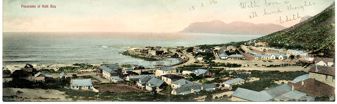 Kalk Bay panorama c 1905. Mike Walker
Looking left to right: At extreme left next to the rail line is the goods shed (now Cape to Cuba). The large double storey on Main Road is Kings Hotel. Buildings in the middle foreground line Windsor Road (Die Middedorp); On the Point are a number of dwellings and the square Kalk Bay Fish & Land Co. building. On Fishery Beach some 20 boats line the foot of the rail viaduct (built 1890). On the mountain footslope known as Die Land are rows of fishermen’s cottages; Clairvaux House (double gable-end) faces the sandy Outspan and future Clairvaux Road (built c. 1929).
![]()
Click HERE for information on the Main Road Muizenburg to Clovelly Historical Interpretive Boards.
Kalk Bay (Afrikaans: Kalkbaai) is a fishing village on the coast of False Bay some 25 km from the centre of Cape Town. A literal translation from the Dutch/Afrikaans name “Kalkbaai” is “Lime Bay”. This derives from the deposits of mussel shells that were found here, which early settlers burned to make lime for construction.
The first written mention of Kalk Bay was in 1687 when Governor Simon van der Stel noted that there was an abundance of fish in the area. It is probable that free burghers were at Kalk Bay by this time burning shells for lime and providing fish for the slaves of Cape Town.
Under the British, whaling became a highly profitable business and between about 1806 and 1850 many whales were processed at Kalk Bay, before stocks were nearly wiped out. It is probable that slaves and free blacks lived here from the early 1800s. In 1812 the whalers Cloete, Reitz and Anderson took transfer of a property near Fishery Beach from the free black Abraham Klopper. Many of the early fishing families would have been Muslim with their origins in Java and Batavia. Following the emancipation of slaves in 1834 the fishing population would have grown further.
A further spurt of growth was provided by the arrival of the Filipinos, Spanish-speaking Roman Catholics, around the 1850s. Many Filipino family names are still to be found in Kalk Bay and some of the language of these renowned seamen is still used in the local fishing taal.
The opening of the railway line from Cape Town in May 1883 followed and was one of the most significant developments in Kalk Bay’s history. It opened up markets for the fishing trade and by 1892 Kalk Bay supplied most of the Cape domestic market. It was also selling over 36 metric tonnes of fish a month to Kimberley and Bloemfontein.
The growing number of white private and business property owners meant the marginalisation of the poorer members of the fishing community. Rental housing became much more expensive and families were increasingly living in squalid and overcrowded conditions, much of it in the area known as Die Land.
The passing of the Slums Act in 1934 meant the area of Die Land (south of Clairvaux Road) was targeted for slum clearance. After much protest by the fishermen and local residents the Kalk Bay Housing Scheme was approved in 1938 and the Fishermen’s Flats were built between 1941 and 1945. A section of the beach was also reserved for ‘fisher families and their friends’.
In 1967 Kalk Bay was proclaimed a white area in terms of the Group Areas Act. This was a blow to the entire community and widespread local opposition followed. In a unique about-face the Government allowed families in the Fishermen’s Flats to stay another 15 years. Many other families in Kalk Bay were not so fortunate and best estimates are that 22 families (about 25% of families) were forced out with all the heartbreak that entailed. The 15 year extension was never acted upon and Kalk Bay is fortunate to have retained its unique multiracial / multicultural character.