
Page 76 - KBHA Bulletin 12
P. 76
73
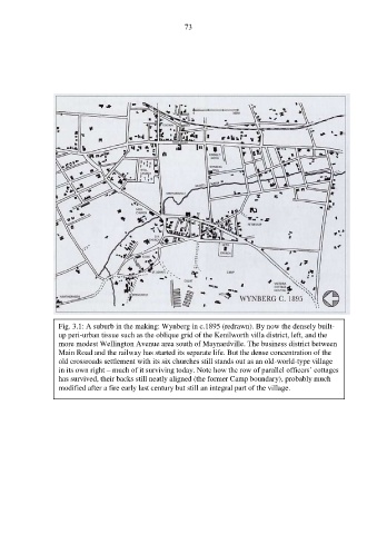
Fig. 3.1: A suburb in the making: Wynberg in c.1895 (redrawn). By now the densely built-
up peri-urban tissue such as the oblique grid of the Kenilworth villa district, left, and the
more modest Wellington Avenue area south of Maynardville. The business district between
Main Road and the railway has started its separate life. But the dense concentration of the
old crossroads settlement with its six churches still stands out as an old-world-type village
in its own right – much of it surviving today. Note how the row of parallel officers’ cottages
has survived, their backs still neatly aligned (the former Camp boundary), probably much
modified after a fire early last century but still an integral part of the village.