
Page 37 - Bulletin 23- 2020
P. 37
33
1800-size. At many places on the periphery, the bank areas had been “reclaimed” using
dredged material from the vlei and there was an extensive dumping of builder’s rubble. On
the eastern shore of the vlei the Municipality of Cape Town had created a large area for the
dumping of municipal refuse. In the 1960s Sandvlei, as an open water body, was
disappearing. (Figs. 2.1 – 2.4).
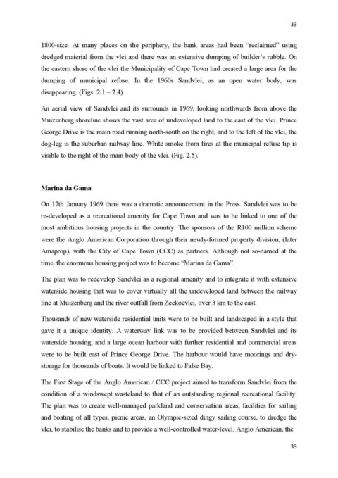
An aerial view of Sandvlei and its surrounds in 1969, looking northwards from above the
Muizenberg shoreline shows the vast area of undeveloped land to the east of the vlei. Prince
George Drive is the main road running north-south on the right, and to the left of the vlei, the
dog-leg is the suburban railway line. White smoke from fires at the municipal refuse tip is
visible to the right of the main body of the vlei. (Fig. 2.5).
Marina da Gama
On 17th January 1969 there was a dramatic announcement in the Press. Sandvlei was to be
re-developed as a recreational amenity for Cape Town and was to be linked to one of the
most ambitious housing projects in the country. The sponsors of the R100 million scheme
were the Anglo American Corporation through their newly-formed property division, (later
Amaprop), with the City of Cape Town (CCC) as partners. Although not so-named at the
time, the enormous housing project was to become “Marina da Gama”.
The plan was to redevelop Sandvlei as a regional amenity and to integrate it with extensive
waterside housing that was to cover virtually all the undeveloped land between the railway
line at Muizenberg and the river outfall from Zeekoevlei, over 3 km to the east.
Thousands of new waterside residential units were to be built and landscaped in a style that
gave it a unique identity. A waterway link was to be provided between Sandvlei and its
waterside housing, and a large ocean harbour with further residential and commercial areas
were to be built east of Prince George Drive. The harbour would have moorings and dry-
storage for thousands of boats. It would be linked to False Bay.
The First Stage of the Anglo American / CCC project aimed to transform Sandvlei from the
condition of a windswept wasteland to that of an outstanding regional recreational facility.
The plan was to create well-managed parkland and conservation areas, facilities for sailing
and boating of all types, picnic areas, an Olympic-sized dingy sailing course, to dredge the
vlei, to stabilise the banks and to provide a well-controlled water-level. Anglo American, the
33