
Page 14 - KBHA Bulletin 9
P. 14
11
that land loomed unexpectedly close by.
The approach to the West Coast was different. Ships made wide arcs into the Atlantic, even
landing on the Brazilian coast before making the southeast crossing towards the Cape. The
West coast was plotted relatively accurately on the charts and could be more easily
followed with fewer navigational misjudgements. The “rogue waves” caused by the quick
rise in the continental shelf close to the African landmass do not occur on the South African
West Coast making sailing conditions relatively safer.
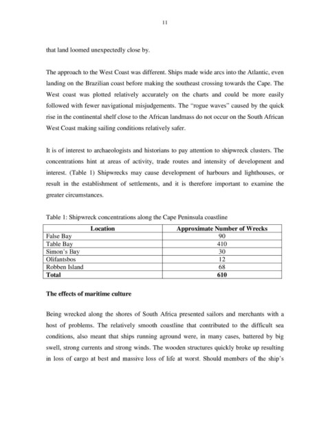
It is of interest to archaeologists and historians to pay attention to shipwreck clusters. The
concentrations hint at areas of activity, trade routes and intensity of development and
interest. (Table 1) Shipwrecks may cause development of harbours and lighthouses, or
result in the establishment of settlements, and it is therefore important to examine the
greater circumstances.
Table 1: Shipwreck concentrations along the Cape Peninsula coastline
Location Approximate Number of Wrecks
False Bay 90
Table Bay 410
Simon’s Bay 30
Olifantsbos 12
Robben Island 68
Total 610
The effects of maritime culture
Being wrecked along the shores of South Africa presented sailors and merchants with a
host of problems. The relatively smooth coastline that contributed to the difficult sea
conditions, also meant that ships running aground were, in many cases, battered by big
swell, strong currents and strong winds. The wooden structures quickly broke up resulting
in loss of cargo at best and massive loss of life at worst. Should members of the ship’s