
Page 101 - KBHA Bulletin 14
P. 101
97
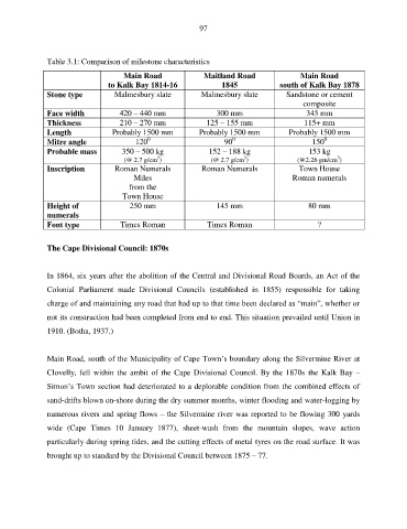
Table 3.1: Comparison of milestone characteristics
Main Road Maitland Road Main Road
to Kalk Bay 1814-16 1845 south of Kalk Bay 1878
Stone type Malmesbury slate Malmesbury slate Sandstone or cement
composite
Face width 420 – 440 mm 300 mm 345 mm
Thickness 210 – 270 mm 125 – 155 mm 115+ mm
Length Probably 1500 mm Probably 1500 mm Probably 1500 mm
0
0
0
Mitre angle 120 90 150
Probable mass 350 – 500 kg 152 – 188 kg 153 kg
3
3
3
(@ 2.7 g/cm ) (@ 2.7 g/cm ) (@2.26 gm/cm )
Inscription Roman Numerals Roman Numerals Town House
Miles Roman numerals
from the
Town House
Height of 250 mm 145 mm 80 mm
numerals
Font type Times Roman Times Roman ?
The Cape Divisional Council: 1870s
In 1864, six years after the abolition of the Central and Divisional Road Boards, an Act of the
Colonial Parliament made Divisional Councils (established in 1855) responsible for taking
charge of and maintaining any road that had up to that time been declared as “main”, whether or
not its construction had been completed from end to end. This situation prevailed until Union in
1910. (Botha, 1937.)
Main Road, south of the Municipality of Cape Town’s boundary along the Silvermine River at
Clovelly, fell within the ambit of the Cape Divisional Council. By the 1870s the Kalk Bay –
Simon’s Town section had deteriorated to a deplorable condition from the combined effects of
sand-drifts blown on-shore during the dry summer months, winter flooding and water-logging by
numerous rivers and spring flows – the Silvermine river was reported to be flowing 300 yards
wide (Cape Times 10 January 1877), sheet-wash from the mountain slopes, wave action
particularly during spring tides, and the cutting effects of metal tyres on the road surface. It was
brought up to standard by the Divisional Council between 1875 – 77.