
Page 16 - KBHA BULLETIN 8
P. 16
13
Owen pardoned him and he served well and uncomplainingly until his death of malaria just
two years later. Malaria, contracted from the miasma rising from the mudflats and river
mouths on the East Coast, resulted in the deaths of more than two thirds of Owen’s officers
and half of his men.
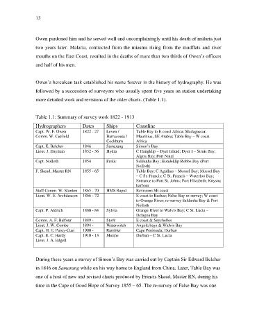
Owen’s herculean task established his name forever in the history of hydrography. He was
followed by a succession of surveyors who usually spent five years on station undertaking
more detailed work and revisions of the older charts. (Table 1.1).
Table 1.1: Summary of survey work 1822 - 1913
Hydrographers Dates Ships Coastline
Capt. W. F. Owen 1822 - 27 Leven / Table Bay to E coast Africa; Madagascar,
Comm. W. Cutfield Barracouta / Mauritius, SE Arabia; Table Bay – W coast
Cockburn Africa
Capt. E. Belcher 1846 Samarang Simon’s Bay
Lieut. J. Dayman 1852 - 56 Hydra C Hangklip – Dyer Island; Dyer I – Struis Bay;
Algoa Bay; Port Natal
Capt. Nolloth 1854 Frolic Saldanha Bay; Hondeklip Robbe Bay (Port
Nolloth)
F. Skead, Master RN 1855 - 65 Table Bay; C Agulhas – Mossel Bay; Mossel Bay
– C St. Francis; C St. Francis – Waterloo Bay;
Entrance to Port St. Johns; Port Elizabeth; Knysna
harbour
Staff Comm. W. Stanton 1865 - 70 HMS Rapid Revisions SE coast
Lieut. W. E. Archdeacon 1866 - 72 E coast to Bashee; False Bay re-survey; W coast
to Orange River; re-survey Saldanha Bay & Port
Nolloth
Capt. P. Aldrich 1880 - 84 Sylvia Orange River to Walvis Bay; C St. Lucia –
Delagoa Bay
Comm. A. F. Balfour 1889 - Stork E coast & Seychelles
Lieut. J. W. Combe 1894 - Waterwitch Angola bays & Walvis Bay
Capt. H. E. Purey-Cust 1900 - Rambler Cape Peninsula; Durban
Capt. E. C. Hardy 1910 - 13 Mutine Durban – C St. Lucia
Lieut. J. A. Edgell
During these years a survey of Simon’s Bay was carried out by Captain Sir Edward Belcher
in 1846 on Samarang while on his way home to England from China. Later, Table Bay was
one of a host of new and revised charts produced by Francis Skead, Master RN, during his
time in the Cape of Good Hope of Survey 1855 – 65. The re-survey of False Bay was one