
Page 73 - KBHA Bulletin 14
P. 73
69
again attempt a landing at Simon’s Bay. In fact there is no other road to Cape Town but at the
foot of this mountain washed by the waves of False Bay. It is the Thermopylae of the Cape; and
so strong a position that, with the assistance of the several breast-works constructed while in our
possession, a chosen band of 300 riflemen might stop the progress of an army.”
Barrow, pp. 230-31.
For Burman this posed a question of fundamental military tactics: “What use would such a pass
have been if the high road had run over the mountains, by-passing this post? Why had the British
stormed Muizenberg in 1795 if they could have avoided it?”
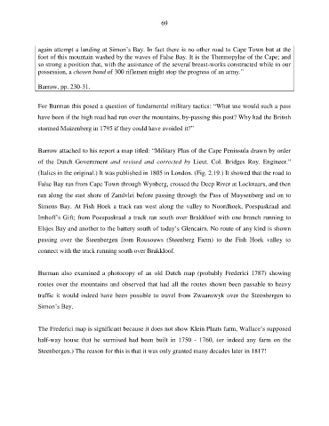
Barrow attached to his report a map titled: “Military Plan of the Cape Peninsula drawn by order
of the Dutch Government and revised and corrected by Lieut. Col. Bridges Roy. Engineer.”
(Italics in the original.) It was published in 1805 in London. (Fig. 2.19.) It showed that the road to
False Bay ran from Cape Town through Wynberg, crossed the Deep River at Locknaars, and then
ran along the east shore of Zandvlei before passing through the Pass of Muysenberg and on to
Simons Bay. At Fish Hoek a track ran west along the valley to Noordhoek, Poespaskraal and
Imhoff’s Gift; from Poespaskraal a track ran south over Brakkloof with one branch running to
Elsjes Bay and another to the battery south of today’s Glencairn. No route of any kind is shown
passing over the Steenbergen from Rousouws (Steenberg Farm) to the Fish Hoek valley to
connect with the track running south over Brakkloof.
Burman also examined a photocopy of an old Dutch map (probably Frederici 1787) showing
routes over the mountains and observed that had all the routes shown been passable to heavy
traffic it would indeed have been possible to travel from Zwaanswyk over the Steenbergen to
Simon’s Bay.
The Frederici map is significant because it does not show Klein Plaats farm, Wallace’s supposed
half-way house that he surmised had been built in 1750 - 1760, (or indeed any farm on the
Steenbergen.) The reason for this is that it was only granted many decades later in 1817!